WHAT! ANOTHER ROAD TRIP? PART 2
We exited Mt. Rainier National Park through the South to U.S. Highway 12 which wends its way between Mt. Rainier on the North and Mt. St. Helens on the South. The nearest road to St. Helens was closed because of snow. We could have gone the long way and entered through a different entrance, but it was an extra hundred miles or so, and we needed to get to civilization for the evening. I last visited Mt. St. Helens in early 1981, not long after its violent eruption. I was single then and made the trip by myself. It was incredible. The volcano was still smoking and volcanic ash several feet deep lined the roads. Many square miles of trees were leveled. It's been over 30 years, and I was happy to see that the forest has largely recovered.
Highway I-5 comes down through Southern Washington state into Portland. There we turned East along the picturesque Columbia River Gorge. Interstate 84 is the most scenic superhighway I have ever driven. It is difficult to keep your eyes on the road when you can see the strangely beautiful rock formations and bluffs on both banks of the river. The farmers in this region grow fruits and vegetables--especially cherries, peaches and strawberries. Wineries and breweries court the tourist trade. Nobody goes thirsty here! To our South, in the setting sun, we could clearly see the pointy snow capped peak of Mt. Hood.
THE DALLES, OREGON
As evening fell, we decided to stop for rest in The Dalles, a town of about 14,000, located about 60 miles West of Portland on the Columbia River. Nearby is the strangely named Horsethief Lake, a popular camping area upstream behind The Dalles Dam. U.S. Corps of Engineers gave the lake its unusual name in the 1950's. They saw the horses kept by the local Indians and imagined that the terrain resembled that of popular Western movies. Well it seemed like a good name!
The Dalles is a historic town. It was named by French Canadian fur traders who camped in the area. The French word dalle means "flagstone" which describes the basalt columns carved out by the Columbia River. To read the brochure "Historic Downtown The Dalles" one would think the main industry in its early days was prostitution. The madams included Big Betty Ramsey who would drive around town in the summer in her Buick convertible greeting the judges and mayor by name. No word on how enthusiastically they returned the greeting. The upstairs at the old Washington Hotel was home to Madam Nora Miller who ran one of the cleanest brothels in town. In the early 1900's, a fire claimed the hotel, and the mayor was heard to exclaim, "You know, its kinda like watching your ol' Alma Mater burn."
Today the town is the county seat of Wasco County, but the economic engine is the dam and the truck farms and wineries in the area. Not mentioned in the guidebooks was the notorious 1984 bio terror attack when a group of Indians from a nearby commune attempted to take over the county government by deliberately spreading salmonella at 10 local restaurants just before the election in the hope that enough people would get sick to swing the election to their candidates. This sounds like something out of Michael Crichton, but it really happened. As it turned out 751 people were poisoned, 45 were hospitalized, but none died. In the words of Archie Bunker, "people in communes are Commun-ists."
Obviously the followers of Bhagwan Shree Rajneesh had much to learn about fixing elections either the Russian way or the Chicago way--all they had to do was register the people in the cemeteries. In any event, the FBI investigation found the bacteria sample matched that at the Rajneeshpurum medical laboratory, and the Indian group's top officials went to the Happy Hunting Ground--at the Federal Pen. The good citizens of The Dalles were spared the spectacle of city council meetings conducted in Gujarati.
A wonderful museum captures history at the Columbia Gorge Discovery Center just West of town.
Most of it is devoted to geology and paleontology with large murals of mammoths. Especially interesting to me was the explanation of how the Columbia River Gorge was formed--by a series of floods--inundations--from melting snow at the end of the last Ice Age. The ice was a mile thick, and when it melted a wall of water came roaring down the canyon taking everything with it.
THE CASCADES
We turned South through Oregon's fertile central valley and drove on back roads in the shadow of the Cascades on our right for hundreds of miles. first it was the stately Mt. Hood for much of that distance and then Mt. Jefferson which was originally called Mt. Vancouver when it was named by the British. Our old friends Lewis and Clark renamed this volcano after their mentor President Thomas Jefferson. It's last eruption occurred in 950 A.D. How do we know that? It was probably revealed by a study of tree rings. Keep in mind the local Indians used a different calendar--they didn't number their years. Incidentally, Mt. Hood last erupted in 1865.
Anyway you slice it, the Pacific Northwest has more volcanoes--recently active ones--than any other part of the continental U.S. Just outside Bend, OR, in the central part of the state is Newberry National Volcanic Monument, a testament to recent past volcanic activity--if one considers 7000 years ago recent. We explored the Visitor's Center there before climbing Lava Butte, a cinder cone rising 510 feet above the plain. We drove up the steep winding road one and a half miles to the peak where an observatory was built with a commanding view of the surrounding plains, the black rock lava beds and Newberry caldera. In 1969, 23 U.S. astronauts trained in this rough area for the upcoming moon landings.
One doesn't normally think of Oregon as a desert, but the central part of the state is covered with desert vegetation. The Cascade Range to the West captures most of the precipitation from the Pacific Ocean. There, in the mountains, pine forests of fir and spruce thrive. The pine smell is clean and aromatic.
As we made our way into Southern Oregon, we caught a glimpse of the distant Mt. Shasta, 100 miles away in Northern California. We spent the night in Klamath Falls at the Shilo Inn which was a real find! It is a relatively inexpensive hotel a large step above the Super 8's, EconoLodges and even Holiday Inns that we were used to. We felt so comfortable there that we even did our laundry.
NORTHERN CALIFORNIA--MT. SHASTA AND WEED
A few miles inside Northern California is the town of Weed, which seems like an appropriate name for a town in a state where marijuana is one of the leading cash crops. I'm sorry to disappoint everyone, but the town was actually named after an early settler, Abner Weed who built a sawmill there. We don't know what he smoked, but the Chamber of Commerce makes money peddling t-shirts with messages like "Rollin' Weed". Nobody in Weed is complaining as long as the tourists keep coming and buying the t-shirts. Weed is in the shadow of the beautiful Mt. Shasta, a magnet for outdoorsmen--hikers, campers and new agers. About the only notable person from Weed was the long time girl friend of the Doors' Jim Morrison, who had a little too much weed in his system when he died at age 27.
Mt. Shasta was sacred to the Indians living in the area who claimed their gods lived there. Modern conspiracy theorists and UFO buffs picked up on this and contend that the gods were actually aliens. We didn't see any, although some of the Californians we saw looked like they came from another planet. According to Indian legends, everything from Lemurians to elves to aliens had been seen on the mountain. Even Sasquatch and/or bigfoot would show up from time to time. Among the evidence UFO promoters give is that in 1946 (before Roswell), an Air Force pilot reported seeing strange lights flying around Mt. Shasta. To this day, we don't know what he saw, but we can all agree the scenery is awesome. God probably would live there if He could afford it.
We decided to see for ourselves, and took the road up Mt. Shasta where it abruptly ended around the 7000 foot level and we couldn't go any further. The mountain is over 14,000 feet high but pretty much everything above us was covered with snow. People can hike to the top, but our aging bodies aren't in shape to do that. Mr. Shasta, like the other mountains in the Cascade Range is a volcano, but has not erupted since 1786.
COLMA, CALIFORNIA
We stayed for three nights in the San Francisco East Bay area. Having some free time, we decided to visit the town of Colma, just down the peninsula from San Francisco. We had to cross the San Francisco Bay Bridge which is a toll bridge. The toll is $6 until 10 A.M. at which time it drops to $4. We arrived at the bridge at 9:58 A.M.. Darned if we were going to pay the extra $2. Everyone else on the road had the same thought. Hundreds of cars crept along at s snail's pace until the stroke of 10 when we all went through at $4.
The main industry in Colma is cemeteries. According to the sign, the population is only 101. That's live people. There's at least 1 million dead ones. The town motto is "It's great to be alive in Colma." We were looking for the legendary Western sheriff, Wyatt Earp who is buried at Hills of Eternity, the Jewish cemetery. We had learned about this when we visited Dodge City last year.
We stopped at the cemetery office where the receptionist gave us a photocopied sheet with a map to locate the grave. It's an unremarkable grave and headstone, surprising when you consider that it is the most visited grave in the cemetery. The printed materials explain why Earp was in the Jewish cemetery--his wife Josephine Marcus Earp was Jewish. He and Josie were together for 50 years. In the 1920's, the Earps lived in Los Angeles where they had many friends in the movie industry. Earp died in 1929 at age 81. The cowboy actor Tom Mix was a pallbearer. Earp had no family left, and Josie brought his ashes up to San Francisco where she buried him in her family plot. Josephine died in 1944, and they are buried together, in the same plot with Max Weiss. The cemetery people don't know who Max Weiss was or whether he as a relative. But he'll be forever linked with Wyatt Earp.
I talked a little with the cemetery manager and asked him if anyone else famous was buried there. The only other one was Levi Strauss, who invented blue jeans. Befitting his wealth and status, Strauss's grave was the largest one--a Greek Revival structure.
Other notables buried in Colma.include baseball great Joe DiMaggio, William Randolph Hearst, Gov. Pat Brown (Jerry's father) and A.P. Giannini, who started Bank of America. They are all in the Christian cemeteries.
CARMEL BY THE SEA
Three of us left the San Francisco area--our daughter Lisa caught a ride with us to meet her husband Dan in LasVegas the following day. We had some time to spare, so we decided to take the scenic route down the Coast Highway, California Route 1 through Carmel and Big Sur. We made it to Carmel by lunchtime and cruised around town, admiring the cutesy stores and restaurants.
Carmel is an artist colony town and has been for over 100 years. It was originally settled by bohemians (with a small b) who came down from San Francisco after the 1906 earthquake and set up shop. Over the years, the town's residents have been a who's who of actors, artists and authors. What most of them have in common is their eccentricity. The result is that Carmel has passed some strange laws. For example you (men or women) can't wear high heel shoes (higher than 2") without a permit. The reason is to prevent tripping on the uneven pavement. The good news is that the permit is free. You don't have to hire a
lawyer or go before the City Council.
The other strange law is that the town is dog friendly--to an extreme. Many shops put water bowls and dog biscuits out on the sidewalk. You can eat in a restaurant or stay in a hotel with your dog. Restaurants even have doggie menus. I suppose if Bowser can't eat it all, he gets a doggie bag.
We drove down to the beach and then took the narrow one way street through the residential area skirting the coastline. No cookie cutter houses here--these homes have character, as befitting an artist colony. Most were built in the 1950's and 1960's. The lots are not very big, but the ocean views are worth serious bucks.
Politically, the folks here elected Clint Eastwood mayor. He would scowl at his opponents and get things done. Eastwood's campaign issue was his drive to repeal the law prohibiting selling or eating ice cream on the public street. Essentially, he kicked out the killjoys who would take away your ice cream rights.
BIG SUR
Southbound from Carmel, we followed the twists and turns of Highway 1 along the coast and had lunch at the Rocky Point Restaurant overlooking the ocean. It wasn't cheap, but the view was worth every penny.
Big Sur is the section of the Pacific Coast between Carmel and San Simeon where the Hearst Mansion is located. I could write pages and pages about Hearsst and the Hearst Mansion, but we didn't visit it this time. I can't resist one story about how the newspaperman William Randolph Hearst allegedly started the Spanish-American War in 1898. He sent a photographer down to Cuba to take some war photos. The photographer complained that nothing was happening. Hearst replied, "You take the pictures and I'll provide the war!"
The narrow Highway 1 is carved out of the craggy rocks with little or no shoulder or guardrails for much of it. I glanced out to the right of our car and saw a thousand foot cliff. I held on to the steering wheel a little tighter. The speed limit is 35 mph, and you don't want to speed. You probably don't want to drive this road at night either. When there's no fog, the beautiful scenery can be hypnotizing. It's
easier going Northbound because you feel more safe on the same side as the mountain--except for occasional rockslides.
The road was completed in 1937: a large part was built by prisoners from San Quentin, although author John Steinbeck, among others, also worked on the road. The bridges are engineering marvels stretching from mountain to mountain. The largest is the impressive Bixby Creek Bridge, 700 feet long, including a 310 foot concrete arch span.
At some points the road runs level with the beach. On Piedras Blancas Beach near San Simeon, crowds of people watched the elephant seals plopped down on the sand in every position imaginable. It was mating season, and the scene was one to appeal to most people's prurient interests. These creatures, which weigh up to 4 tons, don't move well on land--they drag themselves along the sand. They are prolific however. They were hunted for their blubber, almost to the point of extinction. Now protected by the government, their numbers have increased exponentially.
Our fuel supply was running law, and it didn't appear we had enough to reach San Luis Obispo, so we looked for a gas station. We were shocked to find the price of gas at $5.89 per gallon. We passed up several gas stations at that price, figuring that it would be less in the next town. You may recall the old Jack Benny routine where the holdup man says, "Your money or your life." Jack Benny replied, "I'm thinking!" That's how I felt. Finally at Ragged Point we bought 20 bucks worth--about 3 gallons, enough to get to San Luis Obispo. As it turned out, at SLO, the gas was in the $4.50 range, expensive, but not highway robbery.
It was probably fortunate that we stopped. Just past Ragged Point we found ourselves in a traffic jam--a long line of stalled cars. No traffic was coming toward us either. Curious, I got out and walked almost a mile to the front of the line and found there had been a terrible accident minutes before. Choppers and ambulances were at the scene. They took almost an hour to clear the narrow road. If we hadn't stopped for gas, that could have been us in the accident.
JAMES DEAN
James Dean fans make their pilgrimage on Cal. 46, the road between San Luis Obispo and Bakersfield. At the intersection with Cal. 41, we find the James Dean Memorial Junction. Movie fans recall that on September 30, 1955, near this intersection, movie star James Dean was speeding along in his Porsche Spyder sports car when he collided with a 1950 Ford Tudor driven by a guy named Donald Turnipseed.
Turnipseed survived the crash. Dean didn't. The James Dean Memorial Junction was dedicated in 2005 on the 50th anniversary of the accident. I got a quick photo of a 40' poster of Dean next to a gas station there.
BARSTOW
After a long trip across the Mohave Desert, the three of us arrived in Barstow at 11 P.M. on a steamy hot Friday night. Barstow is a fair sized town--a railroad center and the crossroads of two Interstate highways. The Santa Fe Railroad, now part of the Burlington Northern operates a switchyard here. Folks making the trip from Los Angeles to Vegas find Barstow a popular rest stop.
Our plan in Barstow was to visit the Route 66 Museum. We tried to visit last year on a Monday, but found it is only open on weekends. It opens at 10 A.M. We had to kill about an hour, so we made our way to the local WalMart where we stocked up on bottled water, potato chips and other essentials.
The Route 66 Museum is staffed by volunteers who have other jobs during the week. It is located next to the luxurious Casa del Desierto which was once a hotel staffed by the Fred Harvey girls. That in itself brings tourists who still watch The Harvey Girls on late night TV. Filmed in 1942, the popular musical starred Judy Garland and Angela Lansbury. Now the hotel is largely a museum, but it still hosts events in the ballroom. It was preparing for a wedding that afternoon. The railroad tracks are a few yards away. At least every hour, a freight train rumbles through, to or from Los Angeles. (See KENSUSKINREPORT, July 28, 2012).
GET ME TO THE GREEK, BAKER, CALIFORNIA
In this part of the country, people have to stop for lunch or free ice water at the brightly colored blue and white Mad Greek Cafe. Without this restaurant, nobody would ever stop here. Baker, CA, the gateway to Death Valley, is one of the hottest places in the country in Summer. Everything bakes in Baker--a fifty foot thermometer across the street goes up to about 130 degrees.
It took us awhile to figure it out but it is evident that the Mad Greek is not mad as in angry, but rather is mad as in crazy. An old saying goes , "Only mad dogs and Englishmen go out in the midday sun," In Baker, that makes perfect sense. This restaurant is the local answer to Wall Drug. Billboards promoting this place extend out for hundreds of miles, and every time we've eaten there, it's been packed! As Yogi Berra said, "Nobody goes there anymore, it's too crowded!"
LAS VEGAS--PAWN STARS
No Western trip is complete without visiting our money in LasVegas. Aside from our usual haunts there, Lisa suggested that we visit the Pawn Stars, a pawn shop in a rundown neighborhood near downtown Las Vegas. Pawn Stars is a popular TV show which I had never watched. Apparently a lot of other people have watched it, because a long line of people stretched down the block waiting to go inside. Standing outside on the sidewalk in 110 degree heat is not a lot of fun. Eventually we were allowed to go inside. They sell a lot of memorabilia of famous people at high prices. They also do a brisk business selling t-shirts and mugs. The shopkeepers quickly size you up to see if you are serious about paying thousands of dollars for some of this stuff. The other 99% of the people will be steered to the t-shirt rack.
WINSLOW, ARIZONA--STANDIN' ON THE CORNER
We drove East through Arizona along old Route 66 and I-40, passing through Kingman, Seligman, Williams (gateway to the Grand Canyon), and Flagstaff (home of the Lowell Observatory where Clyde Tombaugh discovered the planet formerly known as Pluto). We even passed the Barringer Crater, a large hole in the ground formed by a meteorite 50,000 years ago. I've seen it twice before and wasn't about to shell out another 15 bucks apiece to drive over and see it again. However, if you've never seen it, I highly recommend it.
We rolled into Winslow which is known for two things. The first is LaPosada Lodge, a 1929 Spanish style hotel built by the Santa Fe Railroad conveniently next to the train station. In the 1930's, people would get off the train for the night and stay there and be served by the beautiful Fred Harvey girls, the 1930's demure version of the Playboy Club. This hotel has been beautifully restored to its former glory with stone and tile floors, glass murals, antiques and a lush garden. It is notable for some of the people who stayed there in the past. Howard Hughes stayed there several times. Bob Hope stayed there. Charles Lindbergh honeymooned there and designed the airport. Even Albert Einstein stayed there. Although he stayed everywhere else, by most accounts, Al Capone never stayed there.
The other thing putting Winslow on the map is the Eagles' song Take it Easy. The second verse starts out, "I've been standin' on the corner in Winslow, Arizona, such a fine sight to see, a girl my lord in a flatbed Ford, slowin' down to have a look at me..." The LaPosada Lodge had fallen on hard times and the town needed a jumpstart. Then this song came along. The town built a bronze statue of a musician and a flatbed Ford on a street corner, and the merchants in town started promoting this by selling souvenirs. Local donors purchased paving bricks to raise money for the project.
HOLBROOK, ARIZONA
We spent the night in Holbrook, just a few miles from the Petrified Forest National Park. There is not much to see in town but the Wigwam Motel, a Route 66 icon. It consists of 15 wigwams, each 14 feet in diameter and 32 feet high, with running water. I mention it only because a few years back, Oprah Winfrey and her friend Gayle King stayed there on their televised road trip. They lasted about 10 minutes. Get us outta here! We knew better; we stayed at the Howard Johnson.
PETRIFIED FOREST & PAINTED DESERT NATIONAL PARK, ARIZONA
Tucked away in the Northeast corner of Arizona, we find one of the most hauntingly beautiful national parks. The highlight is the 28 mile drive through the park, capturing the colorful moonscapes. Strewn around the desert are huge logs which look like wood, and they once were, but now they're stone and quartz crystals. Some of these logs are 200 million years old! To prevent tourists from walking off with these things, the authorities threaten you with big fines if you step off the paved walkway or if you so much as pick up a rock. The big logs are probably safe from us, you'd need to bring in heavy equipment to move one.
The other interesting thing in the park are the Indian petroglyphs written on boulders. This is the ancients' version of graffiti. The aptly named Newspaper Rock contains more than 650 petroglyphs, with stuff like Running Bear arrested for RUI--riding a horse under the influence of peyote. Actually, I'm making that part up. They won't let you get up close--you have to look through telescopes placed about 100 feet away. Despite that, I was able to take some fairly clear photos of these. They would be more interesting if I could read them.
SOCORRO VERY LARGE ARRAY, NEW MEXICO
We breezed through Pie Town on the Continental Divide. This town was named for a long gone bakery, but is today renowned for its annual pie festival. A few miles down the road we could make out in the distance the huge antennas comprising the Karl G. Jansky Very Large Array (VLA). That was to be the highlight of our trip. Karl Jansky was an engineer who worked for AT&T and is considered the father of radio astronomy. The mother of radio astronomy was Mrs. Jansky.
The VLA is a radio telescope. Radio telescopes are not like normal telescopes that you look through on clear nights. A radio telescope works 24/7, rain or shine (except Christmas and Thanksgiving), scanning the skies for radio waves emanating from distant galaxies and black holes. The VLA consists of 27 enormous dish antennas arranged in a wye (Y) formation on the flat Plains of San Agustin, 50 miles West of Socorro. Each radio dish is 82 feet across and weighs 230 tons. The antennas are on short tracks so they can be rotated or moved slightly to focus better. Taken together, the 27 dish antennas comprise a single radio telescope system with the qualities of a telescope eye 22 miles across, linked to a super-computer to make sense of the data it collects. You can see them from 10 miles away, but they can see things billions of light years away at the edge, if there is one, of the Universe.
One would expect this to be a top secret place, like Area 51, and I felt like I was being watched as I walked around the desert facility, looking at the mechanisms. Many of the buildings are off limits to tourists. The scientists have to process the data. Signs all over insist that your cell phones be turned off because they interfere with the data collected. The antennas are fenced in although one could easily climb over. I didn't do so--or use my cell phone either--I wasn't sure whether snipers were employed. They're not--actually the facility is operated by the National Radio Astronomy Observatory which is part of the National Science Foundation.
The VLA operates a Visitor's Center with exhibits and videos illustrating what a radio telescope does. Much is incomprehensible to the average tourist unless he is a physicist or an astronomer. The VLA sponsors guided tours once a month. Twice a year, they even have a tour to the Trinity Site (first A-Bomb test), about 100 miles away.
SOCORRO, NEW MEXICO
In Socorro, the Chamber of Commerce promotes a walking tour of the historic houses in town. The dominant building in town is the Spanish mission style San Miguel Church, built in 1821. The historic homes are by and large similar to what you would see in any other town--they are old. One, however, caught my eye because of who lived there. The August Hilton House, built in 1912, is a fairly non-descript brick and stucco house in a neighborhood. that has seen better days. Mr. Hilton owned a general store in town. If you've never heard of him, you might be familiar with his son, Conrad who left town and went into the hotel business. Or maybe you'd know of his great-granddaughter, Paris, who is famous for being famous, although we're not sure why.
BILLY THE KID & FORT SUMNER, NEW MEXICO
Fort Sumner is best known for its connection with William H. Bonney, a/k/a Billy the Kid. His name at birth was William Henry McCarty Jr. He also called himself Henry Antrim, using his stepfather's last name. When you've killed 21 people, you have to use a lot of different names. That worked well for him in an era before credit reports and computers.
Historians note that in that era, local newspapers grossly exaggerated and sensationalized his exploits, and part of that may have been promoted by Sheriff Pat Garrett to build up his own reputation. The net effect is that BTK was much more famous than he deserved to be. Hollywood has made at least 24 movies about him.
The town of Fort Sumner has at least 2 museums devoted to BTK, and his memorabilia--his rifle and guns, his boots, his clothing, the list of men he killed, etc. Billy the Kid was 21 when he was shot and killed by Sheriff Garrett in a saloon in 1881. Like Jesse James around the same time, 50 years later several old guys came forward at different times, claiming to be Billy, and that he survived the shooting, escaped and went straight. They may have fooled a few people, but none was ever proven.
A few months before his death, BTK had shot his way out of the Lincoln County Jail, killing the Sheriff, and became a wanted man. The new Sheriff Garrett gathered up a posse and went looking for him. At the museum, you can see the door that BTK stumbled into after being shot. The saloon awnings are there too.
We visited The Kid's grave which also contains his two buddies who were killed a few months later. The headstone is covered in a metal cage because the previous headstones kept walking off. It is located on Billy the Kid Road.
The locals made an effort to present a balanced view of BTK's life. Historical revisionists claim he wasn't such a bad guy after all. In describing him, they use the word "outlaw" in quotes--no worse than "inlaws". The Kid was born in New York City. His mother was an Irish immigrant. His dad, McCarty disappeared and Billy was raised by a single mom. She moved to the West where she married Mr. Antrim. Billy was slightly built and often bullied, and he decided he wasn't going to take it anymore.
His first victim was a blacksmith named Cahill who had beaten him up. BTK shot him, ala George Zimmerman, but he wasn't as fortunate as George. Billy went to jail from where he escaped, climbing up the chimney. He claimed self defense and felt he was wrongfully convicted. On the lam, he made friends, especially females (including married ones)--he was a good dancer. His friends covered for him. He came to Fort Sumner because the nearest lawman was a day's ride away. His luck eventually ran out.
Fort Sumner was built to protect the Navajo Indians. In the 1860's the U.S. Goverenment decided to convert the Navajo into farmers. They said, "We're from the government and we're here to help you." The Feds hired the famed scout Kit Carson to round up 9000 Indians in Arizona and forcibly marched them 400 miles to their new "homes". The "Long Walk" as it is painfully remembered today, caused much suffering and many deaths from starvation, disease and forced labor. Eventually, several years later, the government admitted failure and the Navajo were allowed to return to their former homes.
CLOVIS, NEW MEXICO
The last town as we neared the Texas border is Clovis, New Mexico. Clovis was interesting to us because of its connection to the late rockabilly singer Buddy Holly who recorded That'll be the Day at the Norman Petty Recording Studio. Holley (there's supposed to be an e in his name) was from Lubbock, Texas, about 90 miles away.
This studio is not real well known in town. I had to ask for directions. The cashier in the gas station convenience store across the street didn't know where it was or had even heard of it. Fortunately, another customer pointed it out to me.
One can tour the studio, but you have to make an appointment 30 days in advance. Apparently the guy who owns it doesn't want a lot of tourists like us foraging around, so the doors and gates are locked. We tried. We walked around and knocked at the doors, to no avail. We didn't know about the place in advance, so we couldn't make reservations.
BRAUM'S ICE CREAM
We stayed one night in Pampa, Texas, a sleepy town of 18,000 in the Panhandle. To our pleasant surprise, the most action in town at 9:30 at night was Braum's Ice Cream. Our introduction to Braums was "as good as it gets" to quote their company motto. They had some of the best ice cream we had ever tasted with 12 flavors, along with hot fudge, turtle sundaes, milk shakes and other goodies. We later found Braums in other small cities we passed through in Oklahoma and Missouri. In fact, I checked their website and learned they have almost 300 stores, all concentrated in a five state area. within a 300 mile radius from their home farm in Tuttle, Oklahoma. They make their own ice cream using milk from their own company farms using no hormones, additives, etc. Try it next time you're down there.
PONCA CITY, OKLAHOMA
Ponca City is a small city of 25,000. Its fortunes go up and down in response to the petroleum industry. Ponca City boasts, 2 mansions, open to the public, both once belonging to Ernest W. Marland, who founded the predecessor to Conoco Oil Co. Marland's story sounds like the TV show Dallas. He made a fortune in Pennsylvania oil and lost it in the Panic of 1907. He came to Oklahoma and made another fortune. He was able to borrow enough money to drill a few oil wells. All came up dry until, as he scraped up his last few dollars, Marland hit a gusher on the last one.
He started the Marland Oil Co., made $100 million and lost it a few years later in a hostile takeover by J.P. Morgan Jr. He needed a job, so he went into politics. Marland's personal life was much more interesting. He and his wife, Virginia had no children, so they adopted Virginia's niece and nephew, George and Lydia, who were teenagers at the time. Virginia died in 1926, and two years later, Marland married his (adopted) daughter, Lydia. He was 54 and she was 28. To marry her, he first had to go to court and get the adoption annulled. I didn't know you could do that. The story had a good ending--they were together 13 years until Marland's death in 1941.
Apparently his personal life resonated well with the voters, as he was elected to Congress for one term and then was elected Governor of Oklahoma. A Democrat, he supported FDR's New Deal policies.
I suggested they should make a movie about this guy--then I found out, they are making a movie about him. It will debut next year.
Conoco Oil Co. made out well also. Around the same time Marland made his fortune, Frank Phillips led a somewhat parallel life in a nearby town, Bartlesville, where he made a fortune producing Phillips 66 gasoline. My father once owned a Phillips 66 station. Several years ago, Conoco merged with Phillips Petroleum, and the headquarters of the merged company are now in Bartlesville, Oklahoma, a company town where everything is named after Mr. Phillips.
JOPLIN, MISSOURI
I conclude this story with a salute to the energy and resourcefulness of the citizens of Joplin, MO. a small city devastated by a tornado a couple of years ago. We had dinner in Joplin. Driving from the Intestate to downtown Joplin, we could see where the tornado cut a swath about a mile wide through the town. The people of Joplin got right to work building new homes and businesses. They brought in hundreds of new manufactured houses. Much still remains to be done, but we wish these folks all the best.


Highway I-5 comes down through Southern Washington state into Portland. There we turned East along the picturesque Columbia River Gorge. Interstate 84 is the most scenic superhighway I have ever driven. It is difficult to keep your eyes on the road when you can see the strangely beautiful rock formations and bluffs on both banks of the river. The farmers in this region grow fruits and vegetables--especially cherries, peaches and strawberries. Wineries and breweries court the tourist trade. Nobody goes thirsty here! To our South, in the setting sun, we could clearly see the pointy snow capped peak of Mt. Hood.
THE DALLES, OREGON
As evening fell, we decided to stop for rest in The Dalles, a town of about 14,000, located about 60 miles West of Portland on the Columbia River. Nearby is the strangely named Horsethief Lake, a popular camping area upstream behind The Dalles Dam. U.S. Corps of Engineers gave the lake its unusual name in the 1950's. They saw the horses kept by the local Indians and imagined that the terrain resembled that of popular Western movies. Well it seemed like a good name!
The Dalles is a historic town. It was named by French Canadian fur traders who camped in the area. The French word dalle means "flagstone" which describes the basalt columns carved out by the Columbia River. To read the brochure "Historic Downtown The Dalles" one would think the main industry in its early days was prostitution. The madams included Big Betty Ramsey who would drive around town in the summer in her Buick convertible greeting the judges and mayor by name. No word on how enthusiastically they returned the greeting. The upstairs at the old Washington Hotel was home to Madam Nora Miller who ran one of the cleanest brothels in town. In the early 1900's, a fire claimed the hotel, and the mayor was heard to exclaim, "You know, its kinda like watching your ol' Alma Mater burn."
Today the town is the county seat of Wasco County, but the economic engine is the dam and the truck farms and wineries in the area. Not mentioned in the guidebooks was the notorious 1984 bio terror attack when a group of Indians from a nearby commune attempted to take over the county government by deliberately spreading salmonella at 10 local restaurants just before the election in the hope that enough people would get sick to swing the election to their candidates. This sounds like something out of Michael Crichton, but it really happened. As it turned out 751 people were poisoned, 45 were hospitalized, but none died. In the words of Archie Bunker, "people in communes are Commun-ists."
Obviously the followers of Bhagwan Shree Rajneesh had much to learn about fixing elections either the Russian way or the Chicago way--all they had to do was register the people in the cemeteries. In any event, the FBI investigation found the bacteria sample matched that at the Rajneeshpurum medical laboratory, and the Indian group's top officials went to the Happy Hunting Ground--at the Federal Pen. The good citizens of The Dalles were spared the spectacle of city council meetings conducted in Gujarati.
A wonderful museum captures history at the Columbia Gorge Discovery Center just West of town.
Most of it is devoted to geology and paleontology with large murals of mammoths. Especially interesting to me was the explanation of how the Columbia River Gorge was formed--by a series of floods--inundations--from melting snow at the end of the last Ice Age. The ice was a mile thick, and when it melted a wall of water came roaring down the canyon taking everything with it.
THE CASCADES
We turned South through Oregon's fertile central valley and drove on back roads in the shadow of the Cascades on our right for hundreds of miles. first it was the stately Mt. Hood for much of that distance and then Mt. Jefferson which was originally called Mt. Vancouver when it was named by the British. Our old friends Lewis and Clark renamed this volcano after their mentor President Thomas Jefferson. It's last eruption occurred in 950 A.D. How do we know that? It was probably revealed by a study of tree rings. Keep in mind the local Indians used a different calendar--they didn't number their years. Incidentally, Mt. Hood last erupted in 1865.
Anyway you slice it, the Pacific Northwest has more volcanoes--recently active ones--than any other part of the continental U.S. Just outside Bend, OR, in the central part of the state is Newberry National Volcanic Monument, a testament to recent past volcanic activity--if one considers 7000 years ago recent. We explored the Visitor's Center there before climbing Lava Butte, a cinder cone rising 510 feet above the plain. We drove up the steep winding road one and a half miles to the peak where an observatory was built with a commanding view of the surrounding plains, the black rock lava beds and Newberry caldera. In 1969, 23 U.S. astronauts trained in this rough area for the upcoming moon landings.
One doesn't normally think of Oregon as a desert, but the central part of the state is covered with desert vegetation. The Cascade Range to the West captures most of the precipitation from the Pacific Ocean. There, in the mountains, pine forests of fir and spruce thrive. The pine smell is clean and aromatic.
As we made our way into Southern Oregon, we caught a glimpse of the distant Mt. Shasta, 100 miles away in Northern California. We spent the night in Klamath Falls at the Shilo Inn which was a real find! It is a relatively inexpensive hotel a large step above the Super 8's, EconoLodges and even Holiday Inns that we were used to. We felt so comfortable there that we even did our laundry.
NORTHERN CALIFORNIA--MT. SHASTA AND WEED
A few miles inside Northern California is the town of Weed, which seems like an appropriate name for a town in a state where marijuana is one of the leading cash crops. I'm sorry to disappoint everyone, but the town was actually named after an early settler, Abner Weed who built a sawmill there. We don't know what he smoked, but the Chamber of Commerce makes money peddling t-shirts with messages like "Rollin' Weed". Nobody in Weed is complaining as long as the tourists keep coming and buying the t-shirts. Weed is in the shadow of the beautiful Mt. Shasta, a magnet for outdoorsmen--hikers, campers and new agers. About the only notable person from Weed was the long time girl friend of the Doors' Jim Morrison, who had a little too much weed in his system when he died at age 27.
Mt. Shasta was sacred to the Indians living in the area who claimed their gods lived there. Modern conspiracy theorists and UFO buffs picked up on this and contend that the gods were actually aliens. We didn't see any, although some of the Californians we saw looked like they came from another planet. According to Indian legends, everything from Lemurians to elves to aliens had been seen on the mountain. Even Sasquatch and/or bigfoot would show up from time to time. Among the evidence UFO promoters give is that in 1946 (before Roswell), an Air Force pilot reported seeing strange lights flying around Mt. Shasta. To this day, we don't know what he saw, but we can all agree the scenery is awesome. God probably would live there if He could afford it.
We decided to see for ourselves, and took the road up Mt. Shasta where it abruptly ended around the 7000 foot level and we couldn't go any further. The mountain is over 14,000 feet high but pretty much everything above us was covered with snow. People can hike to the top, but our aging bodies aren't in shape to do that. Mr. Shasta, like the other mountains in the Cascade Range is a volcano, but has not erupted since 1786.
COLMA, CALIFORNIA
We stayed for three nights in the San Francisco East Bay area. Having some free time, we decided to visit the town of Colma, just down the peninsula from San Francisco. We had to cross the San Francisco Bay Bridge which is a toll bridge. The toll is $6 until 10 A.M. at which time it drops to $4. We arrived at the bridge at 9:58 A.M.. Darned if we were going to pay the extra $2. Everyone else on the road had the same thought. Hundreds of cars crept along at s snail's pace until the stroke of 10 when we all went through at $4.
The main industry in Colma is cemeteries. According to the sign, the population is only 101. That's live people. There's at least 1 million dead ones. The town motto is "It's great to be alive in Colma." We were looking for the legendary Western sheriff, Wyatt Earp who is buried at Hills of Eternity, the Jewish cemetery. We had learned about this when we visited Dodge City last year.
We stopped at the cemetery office where the receptionist gave us a photocopied sheet with a map to locate the grave. It's an unremarkable grave and headstone, surprising when you consider that it is the most visited grave in the cemetery. The printed materials explain why Earp was in the Jewish cemetery--his wife Josephine Marcus Earp was Jewish. He and Josie were together for 50 years. In the 1920's, the Earps lived in Los Angeles where they had many friends in the movie industry. Earp died in 1929 at age 81. The cowboy actor Tom Mix was a pallbearer. Earp had no family left, and Josie brought his ashes up to San Francisco where she buried him in her family plot. Josephine died in 1944, and they are buried together, in the same plot with Max Weiss. The cemetery people don't know who Max Weiss was or whether he as a relative. But he'll be forever linked with Wyatt Earp.
I talked a little with the cemetery manager and asked him if anyone else famous was buried there. The only other one was Levi Strauss, who invented blue jeans. Befitting his wealth and status, Strauss's grave was the largest one--a Greek Revival structure.
Other notables buried in Colma.include baseball great Joe DiMaggio, William Randolph Hearst, Gov. Pat Brown (Jerry's father) and A.P. Giannini, who started Bank of America. They are all in the Christian cemeteries.
CARMEL BY THE SEA
Three of us left the San Francisco area--our daughter Lisa caught a ride with us to meet her husband Dan in LasVegas the following day. We had some time to spare, so we decided to take the scenic route down the Coast Highway, California Route 1 through Carmel and Big Sur. We made it to Carmel by lunchtime and cruised around town, admiring the cutesy stores and restaurants.
Carmel is an artist colony town and has been for over 100 years. It was originally settled by bohemians (with a small b) who came down from San Francisco after the 1906 earthquake and set up shop. Over the years, the town's residents have been a who's who of actors, artists and authors. What most of them have in common is their eccentricity. The result is that Carmel has passed some strange laws. For example you (men or women) can't wear high heel shoes (higher than 2") without a permit. The reason is to prevent tripping on the uneven pavement. The good news is that the permit is free. You don't have to hire a
lawyer or go before the City Council.
The other strange law is that the town is dog friendly--to an extreme. Many shops put water bowls and dog biscuits out on the sidewalk. You can eat in a restaurant or stay in a hotel with your dog. Restaurants even have doggie menus. I suppose if Bowser can't eat it all, he gets a doggie bag.
We drove down to the beach and then took the narrow one way street through the residential area skirting the coastline. No cookie cutter houses here--these homes have character, as befitting an artist colony. Most were built in the 1950's and 1960's. The lots are not very big, but the ocean views are worth serious bucks.
Politically, the folks here elected Clint Eastwood mayor. He would scowl at his opponents and get things done. Eastwood's campaign issue was his drive to repeal the law prohibiting selling or eating ice cream on the public street. Essentially, he kicked out the killjoys who would take away your ice cream rights.
BIG SUR
Southbound from Carmel, we followed the twists and turns of Highway 1 along the coast and had lunch at the Rocky Point Restaurant overlooking the ocean. It wasn't cheap, but the view was worth every penny.
Big Sur is the section of the Pacific Coast between Carmel and San Simeon where the Hearst Mansion is located. I could write pages and pages about Hearsst and the Hearst Mansion, but we didn't visit it this time. I can't resist one story about how the newspaperman William Randolph Hearst allegedly started the Spanish-American War in 1898. He sent a photographer down to Cuba to take some war photos. The photographer complained that nothing was happening. Hearst replied, "You take the pictures and I'll provide the war!"
The narrow Highway 1 is carved out of the craggy rocks with little or no shoulder or guardrails for much of it. I glanced out to the right of our car and saw a thousand foot cliff. I held on to the steering wheel a little tighter. The speed limit is 35 mph, and you don't want to speed. You probably don't want to drive this road at night either. When there's no fog, the beautiful scenery can be hypnotizing. It's
easier going Northbound because you feel more safe on the same side as the mountain--except for occasional rockslides.
The road was completed in 1937: a large part was built by prisoners from San Quentin, although author John Steinbeck, among others, also worked on the road. The bridges are engineering marvels stretching from mountain to mountain. The largest is the impressive Bixby Creek Bridge, 700 feet long, including a 310 foot concrete arch span.
At some points the road runs level with the beach. On Piedras Blancas Beach near San Simeon, crowds of people watched the elephant seals plopped down on the sand in every position imaginable. It was mating season, and the scene was one to appeal to most people's prurient interests. These creatures, which weigh up to 4 tons, don't move well on land--they drag themselves along the sand. They are prolific however. They were hunted for their blubber, almost to the point of extinction. Now protected by the government, their numbers have increased exponentially.
Our fuel supply was running law, and it didn't appear we had enough to reach San Luis Obispo, so we looked for a gas station. We were shocked to find the price of gas at $5.89 per gallon. We passed up several gas stations at that price, figuring that it would be less in the next town. You may recall the old Jack Benny routine where the holdup man says, "Your money or your life." Jack Benny replied, "I'm thinking!" That's how I felt. Finally at Ragged Point we bought 20 bucks worth--about 3 gallons, enough to get to San Luis Obispo. As it turned out, at SLO, the gas was in the $4.50 range, expensive, but not highway robbery.
It was probably fortunate that we stopped. Just past Ragged Point we found ourselves in a traffic jam--a long line of stalled cars. No traffic was coming toward us either. Curious, I got out and walked almost a mile to the front of the line and found there had been a terrible accident minutes before. Choppers and ambulances were at the scene. They took almost an hour to clear the narrow road. If we hadn't stopped for gas, that could have been us in the accident.
JAMES DEAN
James Dean fans make their pilgrimage on Cal. 46, the road between San Luis Obispo and Bakersfield. At the intersection with Cal. 41, we find the James Dean Memorial Junction. Movie fans recall that on September 30, 1955, near this intersection, movie star James Dean was speeding along in his Porsche Spyder sports car when he collided with a 1950 Ford Tudor driven by a guy named Donald Turnipseed.
Turnipseed survived the crash. Dean didn't. The James Dean Memorial Junction was dedicated in 2005 on the 50th anniversary of the accident. I got a quick photo of a 40' poster of Dean next to a gas station there.
BARSTOW
After a long trip across the Mohave Desert, the three of us arrived in Barstow at 11 P.M. on a steamy hot Friday night. Barstow is a fair sized town--a railroad center and the crossroads of two Interstate highways. The Santa Fe Railroad, now part of the Burlington Northern operates a switchyard here. Folks making the trip from Los Angeles to Vegas find Barstow a popular rest stop.
Our plan in Barstow was to visit the Route 66 Museum. We tried to visit last year on a Monday, but found it is only open on weekends. It opens at 10 A.M. We had to kill about an hour, so we made our way to the local WalMart where we stocked up on bottled water, potato chips and other essentials.
The Route 66 Museum is staffed by volunteers who have other jobs during the week. It is located next to the luxurious Casa del Desierto which was once a hotel staffed by the Fred Harvey girls. That in itself brings tourists who still watch The Harvey Girls on late night TV. Filmed in 1942, the popular musical starred Judy Garland and Angela Lansbury. Now the hotel is largely a museum, but it still hosts events in the ballroom. It was preparing for a wedding that afternoon. The railroad tracks are a few yards away. At least every hour, a freight train rumbles through, to or from Los Angeles. (See KENSUSKINREPORT, July 28, 2012).
GET ME TO THE GREEK, BAKER, CALIFORNIA
In this part of the country, people have to stop for lunch or free ice water at the brightly colored blue and white Mad Greek Cafe. Without this restaurant, nobody would ever stop here. Baker, CA, the gateway to Death Valley, is one of the hottest places in the country in Summer. Everything bakes in Baker--a fifty foot thermometer across the street goes up to about 130 degrees.
It took us awhile to figure it out but it is evident that the Mad Greek is not mad as in angry, but rather is mad as in crazy. An old saying goes , "Only mad dogs and Englishmen go out in the midday sun," In Baker, that makes perfect sense. This restaurant is the local answer to Wall Drug. Billboards promoting this place extend out for hundreds of miles, and every time we've eaten there, it's been packed! As Yogi Berra said, "Nobody goes there anymore, it's too crowded!"
LAS VEGAS--PAWN STARS
No Western trip is complete without visiting our money in LasVegas. Aside from our usual haunts there, Lisa suggested that we visit the Pawn Stars, a pawn shop in a rundown neighborhood near downtown Las Vegas. Pawn Stars is a popular TV show which I had never watched. Apparently a lot of other people have watched it, because a long line of people stretched down the block waiting to go inside. Standing outside on the sidewalk in 110 degree heat is not a lot of fun. Eventually we were allowed to go inside. They sell a lot of memorabilia of famous people at high prices. They also do a brisk business selling t-shirts and mugs. The shopkeepers quickly size you up to see if you are serious about paying thousands of dollars for some of this stuff. The other 99% of the people will be steered to the t-shirt rack.
WINSLOW, ARIZONA--STANDIN' ON THE CORNER
We drove East through Arizona along old Route 66 and I-40, passing through Kingman, Seligman, Williams (gateway to the Grand Canyon), and Flagstaff (home of the Lowell Observatory where Clyde Tombaugh discovered the planet formerly known as Pluto). We even passed the Barringer Crater, a large hole in the ground formed by a meteorite 50,000 years ago. I've seen it twice before and wasn't about to shell out another 15 bucks apiece to drive over and see it again. However, if you've never seen it, I highly recommend it.
We rolled into Winslow which is known for two things. The first is LaPosada Lodge, a 1929 Spanish style hotel built by the Santa Fe Railroad conveniently next to the train station. In the 1930's, people would get off the train for the night and stay there and be served by the beautiful Fred Harvey girls, the 1930's demure version of the Playboy Club. This hotel has been beautifully restored to its former glory with stone and tile floors, glass murals, antiques and a lush garden. It is notable for some of the people who stayed there in the past. Howard Hughes stayed there several times. Bob Hope stayed there. Charles Lindbergh honeymooned there and designed the airport. Even Albert Einstein stayed there. Although he stayed everywhere else, by most accounts, Al Capone never stayed there.
The other thing putting Winslow on the map is the Eagles' song Take it Easy. The second verse starts out, "I've been standin' on the corner in Winslow, Arizona, such a fine sight to see, a girl my lord in a flatbed Ford, slowin' down to have a look at me..." The LaPosada Lodge had fallen on hard times and the town needed a jumpstart. Then this song came along. The town built a bronze statue of a musician and a flatbed Ford on a street corner, and the merchants in town started promoting this by selling souvenirs. Local donors purchased paving bricks to raise money for the project.
HOLBROOK, ARIZONA
We spent the night in Holbrook, just a few miles from the Petrified Forest National Park. There is not much to see in town but the Wigwam Motel, a Route 66 icon. It consists of 15 wigwams, each 14 feet in diameter and 32 feet high, with running water. I mention it only because a few years back, Oprah Winfrey and her friend Gayle King stayed there on their televised road trip. They lasted about 10 minutes. Get us outta here! We knew better; we stayed at the Howard Johnson.
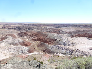
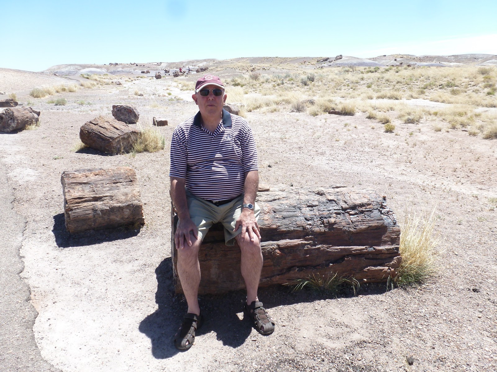
PETRIFIED FOREST & PAINTED DESERT NATIONAL PARK, ARIZONA
Tucked away in the Northeast corner of Arizona, we find one of the most hauntingly beautiful national parks. The highlight is the 28 mile drive through the park, capturing the colorful moonscapes. Strewn around the desert are huge logs which look like wood, and they once were, but now they're stone and quartz crystals. Some of these logs are 200 million years old! To prevent tourists from walking off with these things, the authorities threaten you with big fines if you step off the paved walkway or if you so much as pick up a rock. The big logs are probably safe from us, you'd need to bring in heavy equipment to move one.
The other interesting thing in the park are the Indian petroglyphs written on boulders. This is the ancients' version of graffiti. The aptly named Newspaper Rock contains more than 650 petroglyphs, with stuff like Running Bear arrested for RUI--riding a horse under the influence of peyote. Actually, I'm making that part up. They won't let you get up close--you have to look through telescopes placed about 100 feet away. Despite that, I was able to take some fairly clear photos of these. They would be more interesting if I could read them.
SOCORRO VERY LARGE ARRAY, NEW MEXICO
We breezed through Pie Town on the Continental Divide. This town was named for a long gone bakery, but is today renowned for its annual pie festival. A few miles down the road we could make out in the distance the huge antennas comprising the Karl G. Jansky Very Large Array (VLA). That was to be the highlight of our trip. Karl Jansky was an engineer who worked for AT&T and is considered the father of radio astronomy. The mother of radio astronomy was Mrs. Jansky.
The VLA is a radio telescope. Radio telescopes are not like normal telescopes that you look through on clear nights. A radio telescope works 24/7, rain or shine (except Christmas and Thanksgiving), scanning the skies for radio waves emanating from distant galaxies and black holes. The VLA consists of 27 enormous dish antennas arranged in a wye (Y) formation on the flat Plains of San Agustin, 50 miles West of Socorro. Each radio dish is 82 feet across and weighs 230 tons. The antennas are on short tracks so they can be rotated or moved slightly to focus better. Taken together, the 27 dish antennas comprise a single radio telescope system with the qualities of a telescope eye 22 miles across, linked to a super-computer to make sense of the data it collects. You can see them from 10 miles away, but they can see things billions of light years away at the edge, if there is one, of the Universe.
One would expect this to be a top secret place, like Area 51, and I felt like I was being watched as I walked around the desert facility, looking at the mechanisms. Many of the buildings are off limits to tourists. The scientists have to process the data. Signs all over insist that your cell phones be turned off because they interfere with the data collected. The antennas are fenced in although one could easily climb over. I didn't do so--or use my cell phone either--I wasn't sure whether snipers were employed. They're not--actually the facility is operated by the National Radio Astronomy Observatory which is part of the National Science Foundation.
The VLA operates a Visitor's Center with exhibits and videos illustrating what a radio telescope does. Much is incomprehensible to the average tourist unless he is a physicist or an astronomer. The VLA sponsors guided tours once a month. Twice a year, they even have a tour to the Trinity Site (first A-Bomb test), about 100 miles away.
SOCORRO, NEW MEXICO
In Socorro, the Chamber of Commerce promotes a walking tour of the historic houses in town. The dominant building in town is the Spanish mission style San Miguel Church, built in 1821. The historic homes are by and large similar to what you would see in any other town--they are old. One, however, caught my eye because of who lived there. The August Hilton House, built in 1912, is a fairly non-descript brick and stucco house in a neighborhood. that has seen better days. Mr. Hilton owned a general store in town. If you've never heard of him, you might be familiar with his son, Conrad who left town and went into the hotel business. Or maybe you'd know of his great-granddaughter, Paris, who is famous for being famous, although we're not sure why.
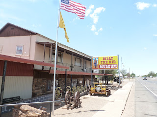
BILLY THE KID & FORT SUMNER, NEW MEXICO
Fort Sumner is best known for its connection with William H. Bonney, a/k/a Billy the Kid. His name at birth was William Henry McCarty Jr. He also called himself Henry Antrim, using his stepfather's last name. When you've killed 21 people, you have to use a lot of different names. That worked well for him in an era before credit reports and computers.
Historians note that in that era, local newspapers grossly exaggerated and sensationalized his exploits, and part of that may have been promoted by Sheriff Pat Garrett to build up his own reputation. The net effect is that BTK was much more famous than he deserved to be. Hollywood has made at least 24 movies about him.
The town of Fort Sumner has at least 2 museums devoted to BTK, and his memorabilia--his rifle and guns, his boots, his clothing, the list of men he killed, etc. Billy the Kid was 21 when he was shot and killed by Sheriff Garrett in a saloon in 1881. Like Jesse James around the same time, 50 years later several old guys came forward at different times, claiming to be Billy, and that he survived the shooting, escaped and went straight. They may have fooled a few people, but none was ever proven.
A few months before his death, BTK had shot his way out of the Lincoln County Jail, killing the Sheriff, and became a wanted man. The new Sheriff Garrett gathered up a posse and went looking for him. At the museum, you can see the door that BTK stumbled into after being shot. The saloon awnings are there too.
We visited The Kid's grave which also contains his two buddies who were killed a few months later. The headstone is covered in a metal cage because the previous headstones kept walking off. It is located on Billy the Kid Road.
The locals made an effort to present a balanced view of BTK's life. Historical revisionists claim he wasn't such a bad guy after all. In describing him, they use the word "outlaw" in quotes--no worse than "inlaws". The Kid was born in New York City. His mother was an Irish immigrant. His dad, McCarty disappeared and Billy was raised by a single mom. She moved to the West where she married Mr. Antrim. Billy was slightly built and often bullied, and he decided he wasn't going to take it anymore.
His first victim was a blacksmith named Cahill who had beaten him up. BTK shot him, ala George Zimmerman, but he wasn't as fortunate as George. Billy went to jail from where he escaped, climbing up the chimney. He claimed self defense and felt he was wrongfully convicted. On the lam, he made friends, especially females (including married ones)--he was a good dancer. His friends covered for him. He came to Fort Sumner because the nearest lawman was a day's ride away. His luck eventually ran out.
Fort Sumner was built to protect the Navajo Indians. In the 1860's the U.S. Goverenment decided to convert the Navajo into farmers. They said, "We're from the government and we're here to help you." The Feds hired the famed scout Kit Carson to round up 9000 Indians in Arizona and forcibly marched them 400 miles to their new "homes". The "Long Walk" as it is painfully remembered today, caused much suffering and many deaths from starvation, disease and forced labor. Eventually, several years later, the government admitted failure and the Navajo were allowed to return to their former homes.
CLOVIS, NEW MEXICO
The last town as we neared the Texas border is Clovis, New Mexico. Clovis was interesting to us because of its connection to the late rockabilly singer Buddy Holly who recorded That'll be the Day at the Norman Petty Recording Studio. Holley (there's supposed to be an e in his name) was from Lubbock, Texas, about 90 miles away.
This studio is not real well known in town. I had to ask for directions. The cashier in the gas station convenience store across the street didn't know where it was or had even heard of it. Fortunately, another customer pointed it out to me.
One can tour the studio, but you have to make an appointment 30 days in advance. Apparently the guy who owns it doesn't want a lot of tourists like us foraging around, so the doors and gates are locked. We tried. We walked around and knocked at the doors, to no avail. We didn't know about the place in advance, so we couldn't make reservations.
BRAUM'S ICE CREAM
We stayed one night in Pampa, Texas, a sleepy town of 18,000 in the Panhandle. To our pleasant surprise, the most action in town at 9:30 at night was Braum's Ice Cream. Our introduction to Braums was "as good as it gets" to quote their company motto. They had some of the best ice cream we had ever tasted with 12 flavors, along with hot fudge, turtle sundaes, milk shakes and other goodies. We later found Braums in other small cities we passed through in Oklahoma and Missouri. In fact, I checked their website and learned they have almost 300 stores, all concentrated in a five state area. within a 300 mile radius from their home farm in Tuttle, Oklahoma. They make their own ice cream using milk from their own company farms using no hormones, additives, etc. Try it next time you're down there.
PONCA CITY, OKLAHOMA
Ponca City is a small city of 25,000. Its fortunes go up and down in response to the petroleum industry. Ponca City boasts, 2 mansions, open to the public, both once belonging to Ernest W. Marland, who founded the predecessor to Conoco Oil Co. Marland's story sounds like the TV show Dallas. He made a fortune in Pennsylvania oil and lost it in the Panic of 1907. He came to Oklahoma and made another fortune. He was able to borrow enough money to drill a few oil wells. All came up dry until, as he scraped up his last few dollars, Marland hit a gusher on the last one.
He started the Marland Oil Co., made $100 million and lost it a few years later in a hostile takeover by J.P. Morgan Jr. He needed a job, so he went into politics. Marland's personal life was much more interesting. He and his wife, Virginia had no children, so they adopted Virginia's niece and nephew, George and Lydia, who were teenagers at the time. Virginia died in 1926, and two years later, Marland married his (adopted) daughter, Lydia. He was 54 and she was 28. To marry her, he first had to go to court and get the adoption annulled. I didn't know you could do that. The story had a good ending--they were together 13 years until Marland's death in 1941.
Apparently his personal life resonated well with the voters, as he was elected to Congress for one term and then was elected Governor of Oklahoma. A Democrat, he supported FDR's New Deal policies.
I suggested they should make a movie about this guy--then I found out, they are making a movie about him. It will debut next year.
Conoco Oil Co. made out well also. Around the same time Marland made his fortune, Frank Phillips led a somewhat parallel life in a nearby town, Bartlesville, where he made a fortune producing Phillips 66 gasoline. My father once owned a Phillips 66 station. Several years ago, Conoco merged with Phillips Petroleum, and the headquarters of the merged company are now in Bartlesville, Oklahoma, a company town where everything is named after Mr. Phillips.
JOPLIN, MISSOURI
I conclude this story with a salute to the energy and resourcefulness of the citizens of Joplin, MO. a small city devastated by a tornado a couple of years ago. We had dinner in Joplin. Driving from the Intestate to downtown Joplin, we could see where the tornado cut a swath about a mile wide through the town. The people of Joplin got right to work building new homes and businesses. They brought in hundreds of new manufactured houses. Much still remains to be done, but we wish these folks all the best.


posted by kensuskinreport at
11:57 AM
![]()
![]()

0 Comments:
Post a Comment
Subscribe to Post Comments [Atom]
<< Home